Neolithic Temples of Malta

The Mediterranean island of Malta figures in the historical record of Europe due to its association with the Knights of St. John of Jerusalem, who fled to Malta from the island of Rhodes in 1530. Yet this small island of 243 square kilometers has far greater importance in European prehistory due to its extraordinary collection of megalithic temples. Situated 80 kilometers south of Sicily and 370 kilometers east of the Tunisian coast, Malta appears to have been first settled during the early Neolithic period by a wave of immigrants from the island of Sicily. This appearance of Neolithic settlement is, however, strongly challenged by new research concerning a probable Paleolithic influence, details of which are presented throughout this essay. Before examining this new research, let us briefly examine the orthodox or conventional theories regarding the origin and nature of human settlements on the island of Malta.
According to the suppositions of orthodox archaeologists, the remains of bones, fragments of pottery, and marks of fire indicate that human beings have lived on Malta since at least 5200 BC. These early people lived in caves but later built huts and villages. Approximately 1600 years after they arrived in Malta, these people began the erection of stupendous megalithic temples. The remaining ruins are the bare skeletons of once magnificent structures, mostly roofed over, paved, furnished with doors and curtains, and beautifully decorated with sculptures and paintings. Some archaeologists assume that the period in which the early Maltese progressed from their first rock-cut common graves to their last massive temple complexes was between 3800 and 2400 BC (assumed because there is absolutely no carbon-datable material associated with the large temples). Around 2300 BC, this extraordinary megalithic culture went into rapid decline. A major cause seems to have been the extreme deforestation and soil loss that accompanied the increase in population and the attendant land clearing for agriculture. Other causes may have been famine, social disruption in response to an oppressive priesthood, and the arrival of foreign invaders. Following the decline of the temple culture, Malta may well have been deserted until the arrival of Bronze Age peoples around 2000 BC.
On the islands of Malta and nearby Gozo, the remains of 50 temples have been found, with 23 in various states of preservation. No particular pattern emerges from the distribution of these temples, and this may be explained by the probability that numerous temples were destroyed in antiquity and that others remain to be discovered. Numerous menhirs and dolmens are scattered across the two islands, but their spatial relationship to the larger temple complexes has not been studied in detail.
Nearly all Maltese temples are constructed in the same basic design: a central corridor leading through two or more kidney-shaped (ellipsoidal) chambers to reach a small alter apse at the far end. The Herculean outer shell of the walls is formed of great blocks of stone propped on the back or edge as orthostats. Internal walls are either piled rough coralline blocks or well-cut slabs set as orthostats. All the walls consist of two faces, the space between being packed with earth or rubble. Doorways and passages all use the trilithon principle: two orthostats parallel to each other to support a horizontal lintel. Frequently, doorways consist of a 'porthole,' in which access is through a rectangular hole in the center of a slab. The temples were probably roofed over with beams, brushwood, and clay (the walls could not have supported the weight of stone roofs; roofing slabs more than two meters in length would have cracked due to their weight, and no remains of stone roofs have been found).
Two different types of limestone were used in the construction of the temples: the hard, gray coralline limestone and the soft, pale globigerina limestone. Both of these stones were deposited in the Miocene geological period. The construction tools available at the time were hand axes made of flint and quartzite, knives and scrapers of volcanic obsidian, wedges of wood and stone, hammers of stone, and wood levers. No metal tools of any kind have been found at the temples. Malta has no mineral resources, and the flint and obsidian found on Malta and Gozo were most probably imported from the islands of Lipari (north of Sicily) and Pantelleria (southwest of Sicily). After the great stone blocks were quarried, they were transported by rollers and levers to the temple sites. At the building sites, the rollers were exchanged for stone balls so that the massive blocks of stone could be moved in any direction, rather than the forward and backward motion possible with rollers.
The earliest interiors were plastered and painted with red ochre. Later, interiors were decorated with intricately carved spirals on steps and altars, friezes of farm animals, fish, and snakes, and a simple pattern of pitted dots. Still evident are wall sockets for wooden barriers or curtains and niches for ritual activities. Some relief decorations are so delicate that it is difficult to understand how they could have been produced using only stone tools. Artifacts and furnishings (now removed from the temples and placed in museums) indicate ancestor worship and oracular and fertility goddess cults. The temples seem to have been used only for ritual activity and not as cemeteries, for no burials have been found. Sacrificial flint knives are among the artifacts discovered in the temples, but there are no human bones, indicating that sacrifices were solely made of animals and not humans.

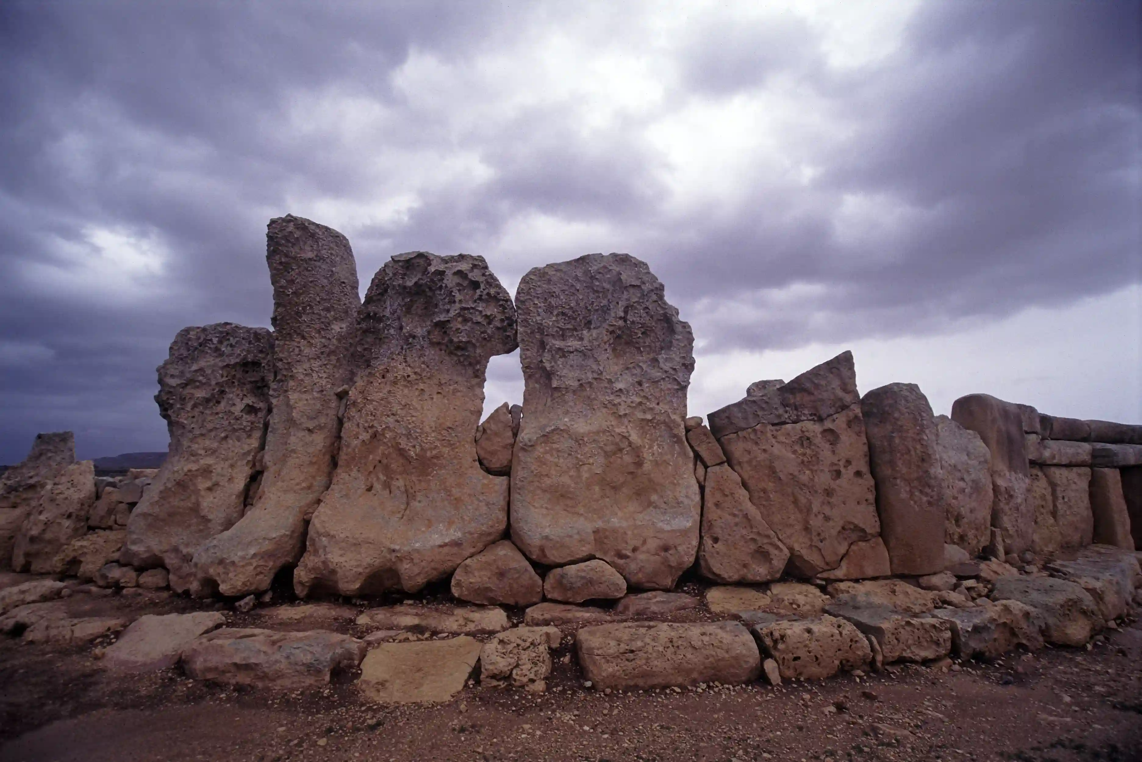
The massive ruins of Hagar Qim (pronounced "agar-eem") and Mnajdra (pronounced "eem-na-eed-rah") stand on a rocky plateau on the southwest coast of Malta, overlooking the sea and facing the uninhabited islet of Filfla, 4.8 kilometers away. This plateau is composed of two types of limestone: the lower, harder stone (gray coralline limestone) from which Mnajdra is constructed and the upper, softer stone (pale globigerina limestone) from which Hagar Qim is built.
The name Hagar Qim means 'standing stones' and previous to the excavations of these ruins all that could be seen was a mound of earth from which only the tops of the tallest stones protruded. Hagar Qim, possibly constructed in several phases between 3500 BC and 2900 BC, is built with some of the largest stones of any temple on Malta; one massive stone is 7 meters by 3 meters (22 ft by 10 ft) and weighs approximately 20 tons. The temple's soft globigerina limestone walls have weathered badly over the millennia, and later, temple builders used the harder coralline limestone, such as found at the Mnajdra complex just down the hill. The ruins were first explored in contemporary times in 1839. Further excavations in 1885 and 1910 produced detailed surveys of the site and repair of some of the damaged structures.
The Mnajdra temple complex is located about 500 meters west of Hagar Qim, closer to the promontory's edge facing the sea. Mnajdra consists of two buildings: a main temple with two ellipsoidal chambers and a smaller temple with one chamber. Among their other possible uses, the temples of Mnajdra fulfilled astronomical observation and calendrical functions. The main entrance faces east, and during the spring and autumn equinoxes, the first rays of light fall on a stone slab on the rear wall of the second chamber. During the winter and summer solstices, the first rays of the sun illuminate the corners of two stone pillars in the passageway connecting the main chambers. Writing in his fascinating book, Underworld: The Mysterious Origins of Civilization, Graham Hancock gives more precise information on these alignments,
- As the sun crests the horizon on the spring and autumn equinoxes, 21 March and 21 September (when night and day are of equal length) its rays exactly bisect the huge Trilithon entrance to Mnajdra's Lower Temple, projecting a spot of light into a small shrine in the deepest recesses of the megalithic complex.
- On the winter solstice (20/21 December, the shortest day) a very distinctive 'slit-image' - looking something like the illuminated silhouette of a poleaxe or a flag flying on a pole - is projected by the sun's rays on to a large stone slab, estimated to weigh 2.5 tonnes, standing to there rear of the west wall of the Lower Temple's northern apse.
- On the summer solstice (20/21 June, the longest day), the same distinctive slit-image appears - but now with the 'flag' oriented in the opposite direction - on a second large stone slab, this time weighing 1.6 tonnes standing to the rear of the west wall of the Lower Temple's southern apse.
Similar to the Mnajdra temple, Hagar Qim has also been shown to have solsticial alignments. Concerning Hagar Qim, Hancock notes that,
Hagar Qim offers several alignments of the summer solstice. One, at dawn, is on the north-east side of the structure, where the sun's rays, passing through the so-called oracle hole, project the image of a disk, roughly the same size as the perceived disk of the moon, on to a stone slab on the gateway of the apse within. As the minutes pass the disk becomes a crescent, then elongates into an ellipse, then elongates still further and finally sinks out of sight as though into the ground. A second alignment occurs at sunset, on the north-west side of the temple, when the sun falls into a V-shaped notch on a distant ridge in line with a forsight on the temple perimeter.
Thus far, little serious research has been conducted on the celestial alignments of the Maltese temples. Further studies are likely to reveal a host of other astronomical orientations. However, one astonishing fact that has emerged from the studies so far concerns an astronomical/mathematical dating of the temples that is many thousands of years older than that assumed by orthodox archaeology. Hancock writes that,
It is well known that the sun's rising points at the solstices are not fixed but vary with the slowly increasing and then decreasing angle of the earth's axis in relation to the plane of its orbit around the sun. These changes in what is known technically as the 'obliquity of the ecliptic' (presently in the range of 23 degrees 27 minutes) unfold over a great cycle of more than 40,000 years and if alignments are sufficiently ancient they will incorporate a degree of error, caused by changing obliquity. From the error it is possible to calculate the exact date of their construction.
In the case of Mnajdra, the alignment today is good but not quite perfect because the rays that form the slit image are projected two centimeters away from the edge of the large slab at the rear of the temple. However, Paul Micallef's calculations show that when the obliquity of the ecliptic stood at 24 degrees, 9 minutes, and 4 seconds, the alignment would have been perfect, with the slit image forming exactly in line with the edge of the slab. This 'perfect' alignment has occurred twice in the last 15,000 years - once in 3700 BC and again, earlier, in 10,205 BC.

In addition to their celestial alignments, the Maltese temples reveal surprising evidence of mathematical and engineering sophistication. One researcher, Gerald Formosa (Megalithic Monuments of Malta), has discovered numerous examples of the so-called Megalithic Yard of 2.72 feet. This mathematical constant, found at megalithic sites throughout the ancient European world, was first brought to scientific attention through the studies of Oxford Professor Alexander Thom. In Hagar Qim and Mnajdra, examples of the Megalithic Yard are found in the measurements of the portal stones and triangles etched on the temple floors.
Orthodox archaeologists mostly ignore these astronomical, mathematical, and engineering findings because Maltese temple architecture is commonly assumed to have developed previous to and independent of any outside influence. D.H. Trump, a noted 'expert' on Malta (Malta: An Archaeological Guide), comments, "There is nothing looking remotely like one of these temples outside the Maltese islands, so we cannot use 'foreign influence' to explain them. The almost complete absence of imported pottery further strengthens the argument." But how, then, are we to explain the enigmatic presence of the Megalithic Yard? This undeniable artifact of great antiquity suggests that the temples of Malta, rather than being isolated ruins, may be part of a pan-regional (or global) sacred geography.
Another mystery concerns the statues of grossly overweight figures found in many of the Maltese temples. Their pleated skirts, generous thighs, and small hands and feet have led them to being called fertility goddess deities. But they are of indeterminate sex, and it has been noticed that the "ladies" have no breasts. As a result, archaeologists have now revised their names to the more accurate term of "obese figures." D.H. Trump comments, "It must be admitted at the start that to describe (these obese statues), as is usually done, as a goddess or 'fat lady' may be no more than male prejudice. The sex is not explicitly indicated. Corpulence in women is frequently, though mistakenly, held to be a sign of fertility. If we call her a goddess from now on, this is a matter of probability and convenience rather than proof." Additionally, figurines of men in skirts, with braided and pig-tailed hair, and numerous examples of carved phalluses demonstrate that the Maltese temples had a general fertility function that included both masculine and feminine elements. Nonetheless, it is true that certain figurines found in Malta, such as the Sleeping Lady and the Malta Venus, show that the Neolithic people of the island possibly had some sort of specific goddess cult.
Other important temple complexes are Tarxien, the Hypogeum, and Tas Silg on Malta and Gigantija on the nearby island of Gozo. The Tarxien site (pronounced "tar-sheen"), discovered by a farmer in 1915, is composed of three temples, one of which contains a famous statue of the lower body of a standing figure. Sometimes interpreted as a goddess statue by feminist writers (there is no way of knowing this as the gender is indeterminate), it is one of the world's earliest known and most powerful representations of a deity (the statue in the temple is a replica, the original being in a museum in the nearby capital city of Valletta.)

Another important temple, the Hypogeum at Hal Saflieni, departs from the norm of Maltese temples. Located close to the Tarxien temple complex in the modern suburb of Paola, it was discovered by chance in 1902 while digging a well. The Hypogeum is a multi-story underground labyrinth (25 x 35 meters) consisting of chambers, halls, corridors, and stairs that were extended deeper and deeper into the soft limestone over the centuries. Constructed (according to the orthodox chronology) between 4000 and 5000 years ago, the Hypogeum was both a sanctuary and a cemetery, and the bones of some 7000 humans have been found. The most impressive chamber, commonly called "the holy of holies," has pillars and lintels that are architecturally remarkable. With its walls coated in red paint, it has been suggested that the chamber was used for animal sacrifices. Another chamber, the so-called Oracular room, has a square niche cut into the wall that may have been used so that a priest's voice could echo around the temple. A mysterious quality of this particular room is that a man's voice will powerfully reverberate around the chamber while the ancient stones all but absorb a woman's voice. The Hypogeum has been closed for much of the 1990s for repair and restoration but is scheduled to be reopened sometime after the beginning of the new millennium.
The recently excavated temple called Tas Silg is unique in Malta in that it shows evidence of continued religious use over thousands of years and by various cultures. Initially constructed as a goddess temple during the megalithic phase, it was used by Bronze Age peoples of the first millennium BC, next incorporated into a sanctuary of Astarte (the Goddess of fertility, beauty and love) established by the Phoenicians in the 8th century BC, maintained and improved by the Carthaginians, used by the neo-Punic natives as a shrine of Astarte-Tanit, adopted by the Romans as a temple of the Goddess Juno, taken over by the Christians in the 4th century AD, and finally becoming the site of an Arab mosque in the 9th century.
The largest and best-preserved Maltese temples are on the small island of Gozo (a 20-minute ferry ride from Malta). Constructed (according to the assumptions of conventional archaeology) between 3600 and 3000 BC, the temple of Gigantija covers 1000 square meters, and its astonishing rear wall still rises 6 meters and contains megaliths weighing in at 40-50 tons. According to local legends, a female giant carved the massive blocks of Gigantija (the word means gigantic) in the south of Gozo.
As mentioned above, orthodox archaeological opinion asserts that the islands of the Maltese archipelago remained uninhabited until roughly 5200 BC, when Neolithic immigrants from the nearby island of Sicily first settled them. For a variety of reasons, this settlement-dating scenario is now highly suspect. Research conducted by several scientists and synthesized, interpreted, and reported by the ancient civilizations scholar Graham Hancock has conclusively shown a human presence on Malta many thousands of years before the dawning of the Neolithic. People came from Sicily during the Neolithic era, but long before that time, another group also journeyed to Malta and lived there.
While gathering research for his book Underworld: The Mysterious Origins of Civilization, Hancock was repeatedly drawn to the study of prehistoric Malta and, particularly, to some issues that contradicted the conventional archaeological assessment of the island. Primary among these was that Malta was too small to have developed and sustained the necessary civilization that gave rise to the enormously sophisticated construction techniques found in the temples of Mnajdra, Hagar Qim, Gigantija, and the Hypogeum. In other words, how do we account for the presence of twenty-three megalithic temples with no architectural antecedents and no evidence of the large amount of local domestic architecture that would have housed the people who built and used the temples? Discussing this matter, Hancock writes,
How are we to explain the fact that the oldest free-standing stone monuments in the world, which by virtue of there size and sophistication unambiguously declare themselves to have been built by a people who had already accumulated long experience in the science of megalithic construction, appear on the archaeological scene on a group of very small islands - the Maltese archipelago - that had not even been inhabited by human beings until 1600 years ago? Isn't this counter-intuitive? Wouldn't one expect a 'civilization history' to show up in the Maltese archaeological record documenting ever-more sophisticated construction techniques - and indeed wouldn't one also expect an extensive 'civilization territory' capable of supporting a reasonably sized population (rather than tiny barren islands) to surround and nourish the greatest architectural leap forward of antiquity?
This notion of a more extensive 'civilization territory' contributing to the development of prehistoric Malta is something that, until a few years ago, was considered impossible. Two scientific disciplines outside of the bounds of orthodox archaeology have recently presented evidence to contradict this notion. Paleoanthropologists excavating in the caves of Ghar Hasan and Ghar Dalam on Malta found evidence of Neanderthal humans along with the skeletal remains of animals (European deer, bear, wolf, and fox) known to be extinct long before the end of the Paleolithic era. While the Neanderthal could conceivably have made the sea voyage from mainland Europe to Malta during early Paleolithic times (though there is no evidence of such sea migrations anywhere in the Neanderthal record), the animals could not have made such a sea journey and would therefore have somehow walked to the region of Malta. But isn't Malta an island remotely located in the midst of a vast sea?
Malta has not always been an island; we learn this fact from oceanographers and the new science of inundation mapping. Around 17,000 years ago, at the time of the Last Glacial Maximum, when the level of the world's oceans was more than 120 meters lower than it is today, the islands of the Maltese archipelago were the mountain tops of one landmass joined by land-bridge to Sicily (90 kilometers to the north), which itself was joined to the southern end of what is today the Italian mainland. Therefore, until 16,400 years ago, Paleolithic humans and the animals they hunted could have walked from Europe to Malta. These people would have lived, hunted (and perhaps farmed) mainly in the lowland areas and (like so many other cultures of antiquity) might have constructed some of their temples upon the peaks of sacred mountains. Given the many thousands of years during which Malta was connected by land to mainland Europe and the likelihood of information exchange from other cultural regions of prehistoric Europe, it is eminently possible that the extraordinary architectural style of the Maltese temples could have been developed.
Then, the ice caps began to melt, and the level of the oceans slowly rose, relentlessly inundating coastal areas and the land bridges between higher altitude regions. By 14,600 years ago, the land bridge to Sicily had disappeared beneath the sea, and by 10,600 years ago, the waters had risen so high that only the peaks of Malta were above the seas, forming the islands we have today of Malta, Gozo, and Comino. In the process of this inundation, the social centers in the lowland regions would have been lost beneath the waters, and the people would have retreated to the higher altitudes of the Maltese peaks or would have migrated northward to Italy and the mainland of the European landmass. The Maltese archipelago would henceforth be completely isolated from European cultural influences and would, therefore, display unique developmental characteristics, precisely the case found in the archaeological record. As Hancock says, "Perhaps this Paleolithic isolation rather than the Neolithic invasion (of 5200 BC from Sicily) was the real genesis of the distinctive character and achievements of Maltese civilization.
Perhaps, too, the great temples of Malta were not constructed during Neolithic times but are, in fact, artifacts of a much older Paleolithic civilization (remember, there is no radio-carbon or other archaeological dating to substantiate the orthodox assumption of a Neolithic origin of the Maltese temples). Perhaps the elegant astronomical alignments of the temples and the presence of advanced mathematics in their construction indicate that the island of Malta was once part of a pan-regional (or global) sacred geography, itself formulated by a long-lost civilization of high scientific and spiritual achievement. To determine the answers to these questions, conducting much more extensive archaeological excavations on Malta and, equally important, at the many underwater archaeological sites surrounding the islands will be necessary. Whatever their ultimate genesis, however, the Maltese temples are places of power that are not to be missed by any serious pilgrim or earth mysteries aficionado.
Also of importance as a pilgrimage site, though of more recent origin than the great megalithic temples, is the Romanesque basilica of Ta' Pinu on the island of Gozo. Legends relate that in 1883, a local woman named Carmel Grima heard a voice telling her to pray when passing a small 16th-century chapel. A friend, Francesco Portelli, affirmed that he had also heard the voice. They prayed together for Francesco's ailing mother, and she soon experienced a miraculous recovery. More miraculous healings were thereafter reported, and from thanksgiving offerings, the present sanctuary was built in the 1920's. This sanctuary incorporates the early chapel, whose original caretaker, Pinu Gauci, lent his name to the site. In addition to being visited for its healing qualities, the Ta' Pinu shrine is sacred to sailors. Inside the shrine is a corridor filled with paintings of shipwrecked sailors saved by the Virgin Mary.

For additional information:

Martin Gray is a cultural anthropologist, writer and photographer specializing in the study of pilgrimage traditions and sacred sites around the world. During a 40 year period he has visited more than 2000 pilgrimage places in 160 countries. The World Pilgrimage Guide at sacredsites.com is the most comprehensive source of information on this subject.