Chichen Itza Facts

The Location of Chichen Itza
Approximately 25 miles (120 kilometers) southeast of Merida stands the ruins of Chichen Itza, the most famous of the Maya archaeological sites in Yucatan.
Contrary to popular belief, the Mayans were not an empire but a collection of autonomous city-states that frequently communicated with other city-states in their region.
Chichen Itza and numerous other important Maya temple cities were positioned according to a regional sacred geography.
The Mayans practiced sacred geography on a large regional scale by placing their temple cities at specific sites that mirrored the positions of various celestial objects observed in the night sky.
History of the Maya Ruins at Chichen Itza
Who built Chichen Itza?
The Maya were an ancient civilization of southern Mexico and the Central American countries of Guatemala, Honduras, Belize, and El Salvador. Today, an estimated 6 million Mayans live in these regions and speak various Mayan languages.
During the first millennium AD, the Maya keenly observed and mapped the movements of the sun, moon, planets, and stars. These celestial objects were incorporated into a complex cosmology and mythology that explained the past and predicted the future.
The Maya developed a brilliant mathematical system, the only writing system known in the Americas, and a series of three precise and interrelating calendars.
The Maya are famous for their grand temple cities of Chichen Itza, Palenque, Uxmal, Tikal, and Copan, among many others. Some of these temple cities have been excavated and reconstructed by archaeologists, while others are still in their unexcavated state.
The Maya built their sophisticated and highly decorated ceremonial architecture without using the wheel, including temple pyramids, palaces, and observatories. While no physical evidence has yet been found of the Mayan use of large wheels for transportation purposes, numerous toys that do have wheels have been discovered. Therefore, it cannot be categorically stated that the Maya did not use larger wheels.
The Maya were highly skilled potters, weavers, sculptors, and jewelers. They developed an extensive trade network through the jungles and along Yucatan and Central America's eastern and western coasts. Through these trade networks, they were able to obtain resources from distant areas, such as obsidian from central Mexico and gold from Central America.
Because no metal cutting tools have thus far been found at any of the Mayan ruins, it has been generally assumed that the Mayans did not use such tools. However, archaeological opinion has shifted over the past few decades. There are several reasons why. One is the intricacy of Maya jewelry, which would have required the smelting and mixing of different metals as well as the use of metal tools, probably bronze, for fashioning the jewelry.
Even though no archaeological finds have confirmed that the Mayans had bronze tools, it is doubtful that during the many centuries, they smelted copper in crucibles, they would not have discovered that adding a small amount of tin would produce hard bronze for their tools.
The boat-making technology of the maritime Chontal Maya also indicates the use of metal. These people, who lived in the coastal regions of northern, western, and eastern Yucatan, are known to have built large canoes with which they sailed throughout the Caribbean Islands, along the Mexican coasts, and to southern Florida. The precision craftsmanship evident in these canoes - known from eyewitness accounts by early Spanish explorers - could only have been done with metal cutting tools.
Besides their ability to construct boats, the Mayan accomplishments in mathematics and astronomy enabled them to develop a sophisticated method of celestial navigation for their overseas voyages.
When was Chichen Itza built?
Proto-Mayan tribes had inhabited the flat limestone plateau that makes up much of the Yucatan peninsula for at least 8000 years.
Archaeologists believe that the site where the temple city of Chichen Itza would later be built was already an important pilgrimage place in the first millennium B.C.
As a Maya social center, Chichen Itza began its rise to prominence with the arrival of seafaring people in the eighth century. Called the Itza by archaeologists, these merchant warriors had first colonized the northern coastal areas of the Yucatan peninsula and then ventured inland. One of their first significant settlement sites was near two large, natural sinkholes, called cenotes, that provided plentiful and pure water throughout the year. Their city became known as Chichen Itza, which means "Mouth of the Well of the Itza." From this site, the Itza Maya rapidly became the rulers of much of the Yucatan peninsula.
Chichen Itza rose to regional prominence towards the end of the Early Classic period or approximately 600 AD. However, towards the end of the Late Classic and into the early part of the Terminal Classic, the site became a major regional capital, centralizing and dominating political, sociocultural, economic, and ideological life in the northern Maya lowlands.
The arts and sciences flourished during the Central Phase of the Classic Period (625 - 800 A.D.). At this time, Chichen-Itza became a religious center of increasing importance, and many of its most significant buildings were constructed.
Toward the end of the Classic Period, from 800 to 925 A.D., the foundations of this magnificent civilization weakened, and the Maya left many of their major religious centers and the rural land around them. New, smaller centers were built, and the great cities like Chichen-Itza were mostly visited only to perform religious rites or bury the dead. The Itza people abandoned their city by the end of the 8th century A.D. and lived on the peninsula's west coast for about 250 years. However, by the 10th century A.D., they had returned to Chichen-Itza.
Some ethnohistoric sources claim that in about 987, a Toltec king named Quetzalcoatl left the city of Tula in central Mexico and came to Chichen Itza with a large army. With the help of local Maya allies, he captured the city and made it his new capital. While some archaeology and history books still ascribe to this claim, it is now known that the Maya occupied Chichen Itza continuously. The Toltec influences found in the art and architecture of certain areas of the great city resulted from the patronage of a cosmopolitan nobility involved in trade with the Toltecs and other Mesoamerican peoples.
Around 1000 A.D., the Itza allied themselves with other powerful regional tribes, and this alliance was favorable to the Itza for about two centuries. During this time, the people of Chichen-Itza added to the site by constructing magnificent buildings bearing the touch of Toltec art: porches, galleries, colonnades, and carvings depicting serpents, birds, and Mexican gods.
In 1194, the city of Mayapan broke the alliance and subdued Chichen Itza. The city was gradually abandoned. The Maya chronicles record that in 1221, a revolt and civil war broke out, and archaeological evidence seemed to confirm that the wooden roofs of the Great Market and the Temple of the Warriors were burned at about this date. Chichen Itza went into decline as rulership over Yucatan shifted to Mayapan.
This long-held chronology, however, has been revised in recent years. As more radiocarbon dates arise out of ongoing work at Chichen Itza, the end of this Maya capital is now being pushed back over 200 years. Archaeological data now indicates that Chichen Itza fell by around AD 1000.
While Chichen Itza was never wholly abandoned, the population declined, and no significant new constructions were built following its political collapse. The Sacred Cenote, however, remained a place of pilgrimage.
In 1531, Spanish Conquistador Francisco de Montejo claimed Chichén Itzá and intended to make it the capital of Spanish Yucatan, but after a few months, a native Maya revolt drove Montejo and his forces from the land.
The Buildings of Chichen Itza and their purposes
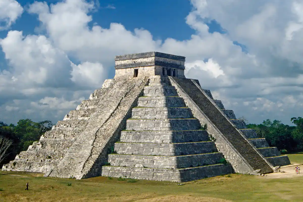
El Castillo, the Pyramid of Kukulkan
The Temple of Kukulkan, the Feathered Serpent God (Quetzalcoatl to the Toltecs and Aztecs), is the largest and most important ceremonial structure at Chichen Itza. The early Spaniards called it El Castillo, meaning the Castle. The pyramid, however, bore no resemblance to a castle and was instead used for religious and astronomical observation purposes.
The ninety-foot tall pyramid was built during the 11th to 13th centuries directly upon the foundations of previous temples. The pyramid's architecture encodes precise information regarding the Mayan calendar and is directionally oriented to mark the solstices and equinoxes. Each face of the four-sided structure has a stairway with ninety-one steps, which, together with the shared step of the platform at the top, add up to 365, the number of days in a year.
Mesoamerican cultures periodically built larger pyramids atop older ones, and the Temple of Kukulkan is one example. In the mid-1930s, the Mexican government sponsored an excavation into the pyramid. After several false starts, they discovered a staircase under the pyramid's north side. They found another temple buried below the current one by digging from the top. Inside the temple chamber was a Chac Mool statue (The Chac-Mool depicted a human figure in a position reclining with the head up and turned to one side, holding a tray over the stomach. The meaning of the position and the statue remains unknown) and a throne in the shape of a jaguar, painted red with spots made of inlaid jade. After installing a set of bars and a locked gate to protect the jaguar figure, they allowed tourists to come and view it, but in 2006, the tunnel leading to the temple chamber was closed to all but archaeologists.
The northern stairway of the pyramid was the principal sacred path leading to the summit. At sunset on the vernal and autumnal equinoxes, the interplay between the sun's light and the edges of the stepped terraces on the pyramid creates a fascinating - and very brief - shadow display upon the sides of the northern stairway. A serrated line of seven interlocking triangles gives the impression of a long tail leading downward to the serpent Kukulkan's stone head at the stairway's base. Adjacent to the head of Kukulkan, a doorway leads to an interior staircase ending at the small shrine with the statue of the Chac Mool. Studies by archaeoastronomers have revealed that other structures at Chichen Itza also have significant astronomical alignments, such as the Caracol observatory, which indicates key positions of the planet Venus, particularly its southern and northern horizon extremes.
The Grand Cenote
Northern Yucatan is arid, and the interior has no aboveground rivers. The only sources of water are the natural sinkholes called cenotes. Some are small, others are large, such as the two at Chichen Itza. Of the two Chichen cenotes, the larger, the "Cenote Sagrado" or Sacred Cenote, is the more famous. According to post-Conquest sources (both Maya and Spanish), the pre-Columbian Maya threw sacrificial objects and human beings into the cenote as a form of worship to Chaac, the Maya rain god. When archaeologists dredged the Cenote of Sacrifice, they found various offerings, including jade carvings, pottery, gold and silver artifacts, and even human skeletons. The Maya also considered the cenote to be an entrance to the underworld, and it is believed that the sacrificial victims were venerating Chac Mool by entering this underworld.
The Caracol celestial observatory
The Observatory at Chichén Itzá is called El Caracol (or snail in Spanish) because it has an interior staircase that spirals upward like a snail's shell. The first structure was probably built during the transition period of the late 9th century and consisted of a large rectangular platform with a stairway on its west side. A round tower about 48 feet high was built atop the platform, with a solid lower body, a central portion with two circular galleries, a spiral staircase, and an observation chamber on the top. Later, a circular and then a rectangular platform were added. The round, concentrically-vaulted Caracol was built and rebuilt several times during its time of use in order to calibrate its astronomical observation capacity. The windows in the Caracol point in the cardinal and subcardinal directions and are believed to enable the tracking of the movement of Venus, the Pleiades, the sun, the moon, and other celestial objects.
The Ball Court
Chichen Itza is also famous for its Great Ball Court, with stone rings 20 feet high upon two of its walls. The ball court has no vault, no discontinuity between the walls, and is totally open to the sky. Each of the northern, southern, and eastern sides supports temples, which were probably used for rituals on the days when the sacred games were played.
Various groups in similar ball courts throughout Mesoamerica played several different ball games. The most widespread game was with a rubber ball, and according to the paintings at various sites, players used their hips to keep the ball in the air as long as possible. Points were gained when the ball was thrown through the stone rings and onto the opposing players’ part of the courtyard.
Sloping benches on the sides of the court were probably used to help keep the ball in play. They are carved with reliefs of the victory celebrations. One of the scenes, the beheading of a player in center field witnessed by the players of both teams, is one of the most dramatic examples of Maya art. The scene not only illustrates the danger faced by the players but also the sacred importance of the game.
It was once thought that the losers were destined to die, but researchers have proposed new theories. Some think that the winning team's captain was sacrificed since his team's triumph made him a fitting offering to the gods. Although played for sport and wagers, the ball game had a definite religious significance. In the Maya creation story, the Popol Vuh, the divine twin heroes play this same game for their lives against the lords of the underworld.
Another fascinating, though seldom discussed, mystery at Chichen Itza concerns the strange acoustic anomalies observable at the great ball court and the temple of Kukulkan. Words softly whispered at one end of the great ball court (measuring 545 feet long by 225 feet wide) are audible at the other end, and a single clap or shout sounded in the center of the ball court will produce nine distinct echoes. Visitors have also commented on a curious acoustic phenomenon at the pyramid of Kukulkan where the sound of a hand clap is echoed back as the chirping sound of the Quetzal bird, the sacred bird associated with both the name of the pyramid and its deity Kukulkan, also known as Quetzalcoatl.
Tourism at Chichen Itza
Chichén Itzá entered the popular imagination in 1843 with the book Incidents of Travel in Yucatan by John Lloyd Stephens and Frederick Catherwood. The book recounted Stephens' visit to Yucatan and his tour of Maya cities, including Chichén Itzá. The book prompted several other city explorations, including Desire Charnay in 1860, Augustus Le Plongeon in 1875, Edward Thompson in 1894, and Sylvanus Morley in 1913.
Fernando Barbachano Peon (a grandnephew of previous Yucatan Governor Miguel Barbachano) started Yucatán's first official tourism business in the early 1920s. In 1944, he purchased the entire site of Chichen Itza and constructed a hotel, which gave further impetus to the growing tourist visitation of the ruins.
In 1961 and 1967, more expeditions were made to recover artifacts from the Cenote Sagrado. National Geographic sponsored the first, and the second was by private interests. Both projects were supervised by Mexico's National Institute of Anthropology and History (INAH).
In 1972, Mexico enacted the Federal Law over Monuments and Archeological, Artistic, and Historic Sites (Ley Federal Sobre Monumentos y Zonas Arqueológicas, Artísticas e Históricas) that put all the nation's pre-Columbian monuments, including those at Chichen Itza, under federal ownership.
Today, the ruins of Chichen Itza are federal property, and Mexico's National Institute of Anthropology and History maintains the site's stewardship. The Barbachano family, however, privately owns the land under the monuments.
In the 1980s, Chichen Itza began to receive an influx of visitors on the day of the spring equinox. At that time, thousands of people come to see the light-and-shadow effect on the Temple of Kukulcan, where the feathered serpent god can be seen crawling down the side of the pyramid.
Over the past several years, INAH has managed the site and has been closing monuments to public access. While visitors can walk around them, they can no longer climb or enter their chambers. The most recent was the El Castillo Temple of Kukulkan, which was closed after a San Diego, California, woman fell to her death in 2006.
Chichen Itza, a UNESCO World Heritage Site, is the second-most visited of Mexico's archaeological sites. The archaeological site draws many visitors from the popular tourist resort of Cancún, who make a day trip on tourist buses. Maps of Chichen Itza are available at the visitor's center next to the ruins, and there is a fine sound and light show in the evenings. Group and private tour guides are also available.


Martin Gray is a cultural anthropologist, writer and photographer specializing in the study of pilgrimage traditions and sacred sites around the world. During a 40 year period he has visited more than 2000 pilgrimage places in 160 countries. The World Pilgrimage Guide at sacredsites.com is the most comprehensive source of information on this subject.